

How Soil Contamination Assessment Finds Hidden Risks
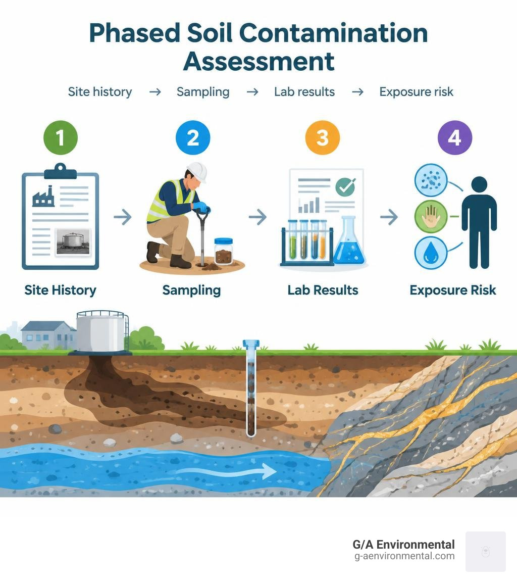
To assess soil contamination, start with the site’s history, then test the places most likely to be affected. A sound assessment identifies possible sources, collects soil samples at relevant depths, and compares lab results with local background levels and standards for the property’s intended use. If a concern remains, further testing can show whether contaminants could reach people through dust, direct contact, or groundwater.
This matters before a purchase or redevelopment. A former fuel tank, industrial activity, or contaminated fill may leave no obvious sign at the surface.
I’m Michael Otto, managing partner at G/A Environmental. My experience with Phase I environmental site assessments across West Texas and Eastern New Mexico helps me identify when a property may need a closer soil contamination assessment.
Fundamentals of Soil Contamination Assessment and Primary Pollutant Sources

Soil serves as a primary foundation for ecosystems, agriculture, and human infrastructure, but it also functions as a long-term sink for hazardous chemical compounds. Because pollutants bind tightly to solid particles or linger in pore spaces, subsurface threats often remain invisible during standard visual walkthroughs. A comprehensive soil contamination assessment bridges the gap between surface observations and hidden subsurface risks by systematically identifying chemical sources, modeling migration vectors, and quantifying concentrations across varying depth horizons.
Whether managing industrial infrastructure, agricultural acreage, or urban infill, identifying contamination early prevents costly regulatory penalties and human health crises. Real estate transactions frequently uncover historical liabilities; for instance, completing a targeted Phase 1 Environmental Site Assessment at a Commercial Building in Midland Texas enables stakeholders to identify historical oilfield activities, solvent storage, or pesticide runoff before capital deployment.
Geogenic Weathering vs. Anthropogenic Industrial Discharges
Contaminants within a soil matrix originate from two broad pathways: geogenic processes and anthropogenic activities.
- Geogenic Sources: Natural pedo-geochemical processes release potentially toxic elements into the surrounding matrix. The chemical weathering of parent bedrock, volcanic ash deposition, and hydrothermal fluid circulation can produce naturally elevated background concentrations of arsenic, chromium, nickel, and cadmium. In these settings, high metal readings reflect local geology rather than commercial mismanagement.
- Anthropogenic Sources: Human activities release concentrated synthetic and inorganic pollutants directly into topsoils. Smelting operations and coal combustion generate atmospheric emissions that settle across regional catchments. Agrochemical applications introduce copper fungicides, arsenical pesticides, and cadmium-rich phosphate fertilizers (which can carry cadmium concentrations up to 500 mg/kg). Heavy industrial discharges, unlined wastewater irrigation lagoons, and legacy leaded gasoline deposition along transportation corridors create localized hot spots that exceed baseline geochemical thresholds.
Fate, Transport, and Physicochemical Soil Controls
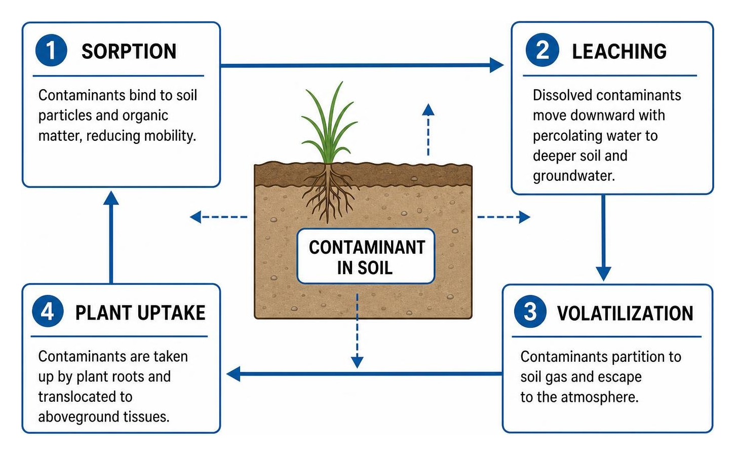
Once a pollutant enters the soil profile, its mobility, ecological bioavailability, and persistence depend on the soil’s internal physicochemical characteristics:
- Soil pH: The master variable governing heavy metal mobility. In acidic soils (pH below 5.5), hydrogen ions outcompete heavy metal cations for exchange sites, causing metals such as cadmium, zinc, and lead to dissolve into porewater where they leach into groundwater or enter plant roots. In alkaline soils, these metals precipitate into insoluble hydroxides or carbonates.
- Soil Organic Matter (SOM): Humic and fulvic acids contain functional groups (carboxyl, phenolic) that form strong chelation complexes with cationic metals and hydrophobic organic compounds, effectively immobilizing them in surface horizons.
- Cation Exchange Capacity (CEC) & Texture: Fine-textured clay soils possess high specific surface areas and strong net negative charges, retaining contaminants far more effectively than coarse, sandy soils, which promote rapid advection and downward leaching.
- Partition Coefficients: These equilibrium ratios, often expressed as Kd (soil-water distribution coefficient) and Koc (organic carbon-water partition coefficient), determine whether a compound remains bound to solid soil particles or dissolves into pore liquids, dictating the balance between long-term retention, volatilization, and deep migration.
Essential Indicators and Chemical Extraction Methodologies

Evaluating soil quality requires analytical testing beyond total element concentrations. A sample with 1,000 mg/kg of total lead bound within an insoluble silicate matrix presents a vastly different biological hazard than one with 200 mg/kg of soluble, bioaccessible lead. Environmental professionals rely on standardized chemical, microbial, and botanical indicators to evaluate immediate and latent toxicity risks, as outlined in foundational technical resources like the FAO Reference Manual on Assessing Soil Contamination.
Tiered Chemical, Microbial, and Botanical Bio-Indicators
- Microbial Indicators: Soil microbes respond rapidly to environmental toxicity. When toxic metals or hydrocarbon residues exceed tolerance limits, microbial biomass carbon drops sharply. Basal respiration rates and the metabolic microbial quotient (MMQ) elevate as stressed cellular communities divert energy from reproduction to basic physiological maintenance. Key soil enzymes—particularly urease, dehydrogenase, and acid phosphatase—experience structural inhibition, serving as early bio-indicators of ecosystem stress long before visual plant symptoms emerge.
- Plant and Botanical Indicators: Native vegetation acts as a biological sensor for subsurface contamination. Excluder species prevent toxic translocation to protect internal physiology, whereas hyperaccumulating plants readily absorb and concentrate heavy metals within their shoots and leaves. Measuring phytotoxicity parameters, such as root elongation inhibition and chlorosis, provides direct insight into bioavailable contaminant fractions in agronomic and ecological settings.
Bioavailability and Sequential Extraction in Soil Contamination Assessment
To differentiate between inert minerals and biologically active elements, laboratory testing uses single-step extractions alongside multi-step sequential fractionation:
- Single-Step Chemical Extractions: Chelating agents like EDTA and DTPA extract organically bound and easily exchangeable fractions to simulate root uptake. Mild acid solutions (such as 0.1 molar hydrochloric acid) and unbuffered neutral salts (such as calcium chloride or ammonium nitrate) isolate water-soluble and weakly adsorbed cations, reflecting the pool immediately available for plant uptake and leaching.
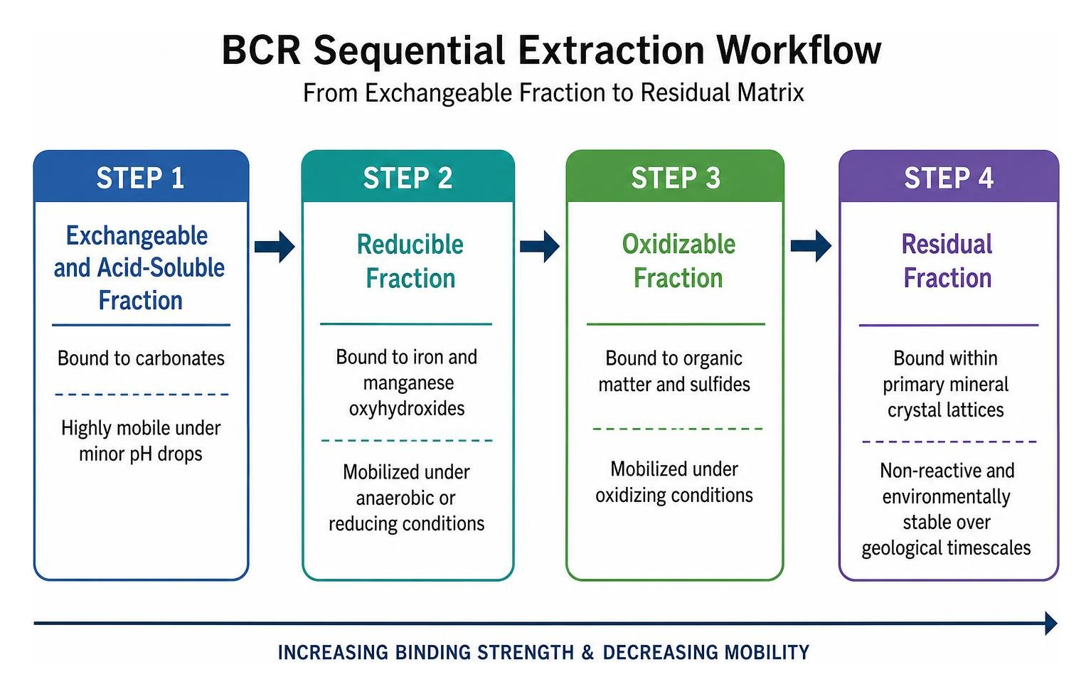
- Sequential Extraction (BCR Protocol): Developed by the European Community Bureau of Reference, this four-stage extraction procedure separates metals into distinct geochemical fractions:
- Step 1 (Exchangeable and Acid-Soluble): Bound to carbonates; highly mobile under minor pH drops.
- Step 2 (Reducible Fraction): Bound to iron and manganese oxyhydroxides; mobilized under anaerobic or reducing conditions.
- Step 3 (Oxidizable Fraction): Bound to organic matter and sulfides; mobilized under oxidizing conditions.
- Step 4 (Residual Fraction): Bound within primary mineral crystal lattices; non-reactive and environmentally stable over geological timescales.
Quantitative Risk Evaluation Models and Toxicological Exposure Pathways
Transforming raw analytical data into actionable risk metrics requires quantitative pollution indices. These tools evaluate whether measured trace element levels reflect natural geochemical baselines or represent severe anthropogenic enrichment.
Strengths and Biases of Single-Factor, Nemerow, and Geo-Accumulation Indices
- Single-Factor Pollution Index: Evaluates a single pollutant by dividing its measured concentration by an environmental standard. While useful for rapid regulatory screening, it fails to account for multi-contaminant mixtures.
- Nemerow Comprehensive Pollution Index: Evaluates overall soil quality by calculating the root mean square of the average and maximum single-factor indices. This model highlights dangerous hotspots, though an isolated spike can skew the entire site classification.
- Geo-Accumulation Index: Originally formulated by Müller, this index quantifies trace metal accumulation above baseline values. It compares the measured concentration of a metal against 1.5 times its natural background level, then expresses the ratio on a logarithmic scale. The 1.5 factor normalizes natural lithogenic variations, separating natural mineralization from industrial deposition. Selecting an appropriate reference background level is essential to prevent false positives. In practical field applications, running a comprehensive environmental site assessment test ensures these calculations reflect accurate local soil composition.
Multi-Pathway Exposure Quantification: Soil-to-Dust Migration and Ingestion
Human health risk assessment evaluates exposure across three main pathways: direct oral ingestion, dermal contact, and inhalation of airborne particulates.
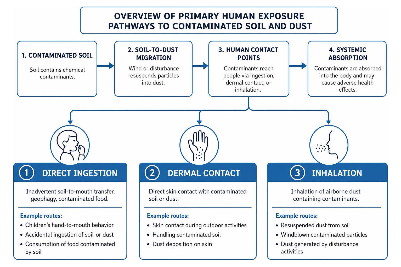
Contaminated exterior soils migrate into indoor living spaces through foot traffic, pets, and wind-driven ventilation. Once indoors, contaminated particles become trapped in carpets and upholstery, sheltered from UV degradation and rainfall dilution. Young children face elevated exposure risks due to frequent hand-to-mouth behaviors, higher breathing rates per unit of body mass, and efficient intestinal absorption.
Standardized Protocols and International Harmonization Frameworks
Accurate site evaluations require standardized investigation protocols that balance data accuracy with practical field execution. International frameworks establish clear guidelines for sample collection, quality control, and risk modeling.
Implementing ISO 18400 and CCME Conceptual Site Models
The ISO 18400-202 Preliminary Investigation Standards establish requirements for preliminary non-intrusive desk studies and site walkovers before initiating drilling. Combining historical land records, aerial photography, and utility blueprints allows project teams to construct an initial Conceptual Site Model (CSM).
As detailed in the CCME Guidance Manual for Environmental Site Characterization, a robust CSM maps complete Source-Pathway-Receptor linkages. If any link in this chain is broken or missing, direct risk is eliminated. The CSM guides sampling grid design, sample depths, and Data Quality Objectives (DQOs) to identify localized hotspots while managing analytical testing costs.
Navigating Background Geochemical Thresholds Across Regulatory Regimes
Environmental standards vary across jurisdictions due to regional geological differences and differing risk management policies. National frameworks such as the New Zealand Contaminated Land Management Guidelines No. 5 and the Malaysian Contaminated Land Management Guidelines No. 2 establish tiered assessment workflows.
Tier 1 compares field concentrations to generic Soil Screening Levels (SSLs). If screening thresholds are exceeded, Tier 2 develops Site-Specific Target Levels (SSTLs) based on measured soil parameters (pH, organic carbon, texture) and intended land use. This tiered structure ensures clean-up requirements address actual biological risks rather than rigid, generic baseline numbers.
Remediation Strategies and Emerging Assessment Technologies
Characterizing subsurface soil conditions enables project teams to select suitable, cost-effective remediation strategies tailored to the target pollutants.
Integrating Remediation Technologies with Assessment Data
- In-Situ Chemical Immobilization: Amendments such as biochar, zero-valent iron (ZVI), agricultural lime, or apatite mineral phases are blended into contaminated soils. These amendments induce precipitation and adsorption reactions that reduce the bioaccessible fraction of heavy metals without generating large volumes of excavated waste.
- Soil Washing: Ex-situ extraction using aqueous solutions, chelating agents, or surfactants separates fine-grained silt and clay particles from coarser sands. This process concentrates heavy metals into a smaller sludge cake, reducing final landfill disposal volumes.
- Phytoremediation: Employs hyperaccumulating plants to extract, stabilize, or volatilize shallow contaminants. While cost-effective and environmentally non-destructive, it requires longer remediation timeframes and is restricted to the upper rooting zone.
When evaluating brownfield redevelopments or managing legacy liabilities, pairing Phase I findings with targeted intrusive testing is essential. For example, completing an Environmental Site Assessment of Commercial Property in Lubbock Texas ensures historical operations and potential fill materials are thoroughly evaluated before finalizing design or remediation plans.
Next-Generation Diagnostics: High-Resolution Sensors and Isotope Fingerprinting
Modern environmental assessments leverage advanced field diagnostics and analytical tools to streamline investigations:
- Field-Portable X-Ray Fluorescence (pXRF): Enables real-time, in-situ screening of heavy metal concentrations. Environmental specialists can screen hundreds of points in a single day, refining sampling grids and delineating contamination boundaries on site.
- Stable Isotope Fingerprinting: Measures precise stable isotope ratios, such as the proportion of lead-206 to lead-207, to distinguish between different contamination sources, such as separating legacy leaded gasoline fallout from industrial coal ash or natural parent rock.
- Geostatistical Machine Learning: Integrates high-density field screening data with GIS kriging algorithms to create detailed 3D subsurface hazard maps, minimizing sampling uncertainty and refining excavation volumes.
Frequently Asked Questions About Soil Contamination Assessment
How does soil pH directly influence the bioavailability of heavy metals?
Soil pH directly controls surface electrical charges and the chemical solubility of metal complexes. In acidic soils (low pH), high concentrations of hydrogen ions (H+) occupy cation exchange sites on clay minerals and organic matter. This forces heavy metal cations such as lead (Pb2+), cadmium (Cd2+), zinc (Zn2+), and nickel (Ni2+) into porewater solution, increasing their availability for plant root uptake, biological toxicity, and downward leaching into underlying aquifers.
What distinguishes total contaminant concentration from the bioaccessible fraction?
Total contaminant concentration measures the entire mass of an element present in the soil matrix, typically extracted using strong acid digestion (such as hydrofluoric acid or concentrated nitric acid). The bioaccessible fraction measures only the portion that dissolves in simulated human gastrointestinal fluids (gastric acid and intestinal enzymes) or mild neutral salts (such as calcium chloride). This bioaccessible fraction represents the actual portion available for physiological absorption into living tissues.
Why is indoor dust sampling critical during a residential soil investigation?
Outdoor soil contaminants migrate indoors via foot traffic, pets, and open windows, settling into carpets, flooring, and furniture fabrics. Indoor dust lacks exposure to direct sunlight, precipitation, and active microbial breakdown, creating a stable, long-term reservoir for heavy metals and semi-volatile compounds. Indoor dust tracking often represents a primary exposure route for crawling infants and young children through frequent hand-to-mouth contact.
Conclusion
Conducting a rigorous, scientifically grounded soil investigation requires a systematic approach: mapping historical activities, identifying geochemical transport controls, deploying targeted sampling techniques, and applying appropriate risk models. Moving beyond basic total concentration figures toward bioavailability-driven risk modeling ensures environmental liabilities are managed effectively, protecting public health while keeping redevelopment projects viable.
At G/A Environmental, we bring over four decades of combined architectural, engineering, and environmental expertise to commercial property owners, industrial developers, and institutional facilities across West Texas and Eastern New Mexico. From initial due diligence and hazardous materials testing to complex subsurface investigations, we help you pinpoint hazards and resolve regulatory liabilities. Contact our team today to schedule your comprehensive Environmental Site Assessment and safeguard your property investments.


